Harrowing statistics for 2100 urge lawmakers and property owners in Florida’s coastal cities to start making decisions about sea level rise. However, the lack of incentive for such decisions puts Florida residents in troubling waters. In this article, we’ll take a look at Florida’s top ten cities most at-risk for property damage due to sea-level rise, and what we as citizens and decision-makers can do to prevent and prepare for these changes.
Florida is America’s most at-risk area for sea level rise. The low elevation, intricate system of waterways, and dense population on the coast puts a majority of Florida residents in danger of having their homes or commercial property damaged due to flooding.
At HighTide, we study these changes and are proactively working with local, regional, and state agencies to prepare for the future. However, many residents in at-risk cities don’t even realize their homes and livelihoods are threatened. Some of the cities most cited in the news do not make our list, while others that don’t border the coast will be considered high-risk in the coming years.
“Common Knowledge” About Sea-Level Rise Is Wrong
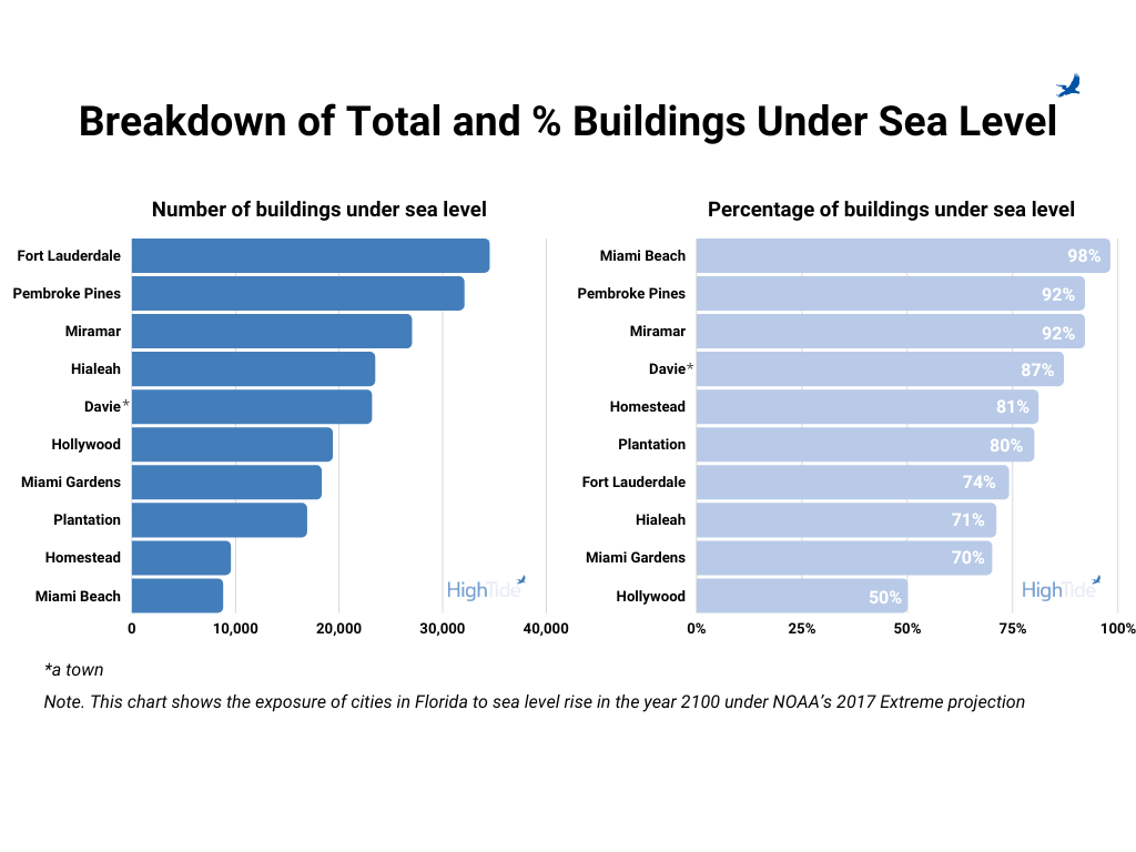
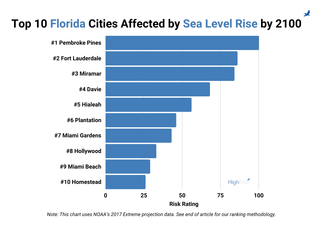
Miami Beach has been the poster city for sea-level rise for some time, and for good reason. By 2100, 98% of buildings in the city could be below sea level. A mild hurricane would likely flood the whole city. Though relatively speaking Miami Beach is one of the most exposed cities in Florida, there are other cities with a higher overall exposure. Based on our ranking methodology, Miami Beach is number 9 on the list of top 10 cities. The sea level rise exposure of the other cities in the list are less publicly known, but those cities would do well to pay close attention to the latest developments on the streets of Miami Beach.
The 2019 Unified Sea Level Rise Projection for Southeast Florida offers three planning projections used for the Southeast Coastal region of Florida:
- By 2040, sea level is projected to rise 10 to 17 inches above 2000 mean sea level (short-term planning impact)
- By 2070, sea level is projected to rise 21 to 54 inches above 2000 mean sea level (mid-term planning impact)
- By 2120, sea level is projected to rise 40 to 136 inches above 2000 mean sea level (long-term planning impact)
These projections are already outpacing NOAA projections from 2012 due to more accurate modeling and constant fluctuations in human and environmental influence. However, where this impact will be felt most is still uncertain. Update: after this writing, NOAA released its updated 2022 projections.
Paleoclimatologist Anders Carlson of the Oregon Glaciers Institute and the NASA Earth Observatory explain the fluctuations in modeling:
“People tend to think that sea level is like a bathtub with the water level simply rising and falling depending on how much water is coming out of the faucet. In reality, it’s more like a spinning bathtub that’s changing shape, moving up and down, and has water pouring into and out of different drains and over the sides. Where the water will ultimately slosh over the edge of the tub is influenced by many things, making it difficult to say where the overtopping will occur.”
Florida is generally considered at risk, but from our risk assessments, it is clear that where that risk will transform into a real threat still remains uncertain in the future. Nowhere is this more clear than in Broward and Miami-Dade counties, where the most at-risk cities are not even on the coast.
Pembroke Pines, And a Warning To Florida’s Future
Pembroke Pines, which reaches the top of our list, is not on the coast at all. It borders the Everglades and is connected to the coast through a series of waterways. Even without the sandy beaches, Pembroke Pines will feel the effects of sea level rise as the water in the intricate pattern of canals rises with the changing patterns of the ocean.
Most of the press about sea level rising focuses on coastal towns. However, any low-lying area connected to the water can be affected. Whether that is through groundwater, man made canals, or other waterways, these cities need to take action as if they were directly on the beach.
Pembroke Pines and others must act now to elevate and restructure for the future well-being of their communities. However, the best adaptation strategies remain unclear without detailed cost-benefit analysis of all the options. Incentives for governments and individual property owners often become muddy, and differences in real estate values raise questions about equity in adaptation.
Troubling Solutions for Threatened Cities
The question now remains – what do cities do to properly prepare for the effects of sea-level rise?
Adaptation strategies that focus heavily on buyouts and removal of at-risk properties raise questions for taxpayers in inner-state areas. Will the decisions made by these coastal towns – or their indecision that will lead to more expensive mitigation – fall on the shoulders of all taxpayers? As the slow-moving sea-level crisis begins to impact larger areas of Florida and the country, the impact will fall not only on municipalities but state and federal governments.
Buyouts of at-risk properties may also provide perverse incentives for property owners to stay in at-risk areas to the detriment of overall adaptation and mitigation strategies. The incentive to act will greatly depend on individual and community attitudes toward adaptation. If property owners are not actively working with the cities and state on adaptation, they may put themselves in danger for the benefit of potential buyouts in the future.
However, the greatest financial risk hangs over low-income areas without the resources or support to provide mitigation solutions on their own. These communities are in need of the most assistance, yet the property tax incentive to invest in them is not as great as in high-income areas. Low-income areas are at risk of being overlooked by projects justified purely by economic cost-benefit analysis.
If we are to avoid these impacts, communities need to buy-in and take action. Equipped with the data to develop mitigation strategies and the foresight to protect both low- and high-income areas will lead to the flourishing of these communities into the future. HighTide provides a unique platform for both high and low-risk communities to prepare for rising sea-levels using AI modeling and the most up-to-date information on flood impacts on coastal regions. To learn more about the HighTide mission and solutions, click here.
Ranking Methodology
To rank the top ten cities exposed to sea level rise in Florida, we counted the total number of buildings permanently under water using the University of Florida’s GeoPlan Center’s Sea Level Rise inundation model for NOAA’s 2017 Extreme projection for 2100. We chose the highest sea level projection to be cautious. As engineers we are trained to consider factors of safety. For example, you wouldn’t want to design a bridge to barely handle the load of cars and trucks. Bridges are designed with a factor of safety to prevent failure, and we believe the same should be done when planning for sea level rise. We considered the total number and percentage of permanently inundated buildings, shown below, and chose to weigh both equally to place an equal emphasis on small and large cities. We kept it simple for this first pass. We’ll add data layers and methods as we zoom in.